Is Chongqing Hard to Navigate? A Local Guide to Transportation and Getting Around Chongqing
Is Chongqing navigation really that difficult? Yes, navigating Chongqing can indeed be disorienting, but once you grasp the three-dimensional structure of this mountain city, Chongqing navigation isn’t nearly as challenging as imagined.
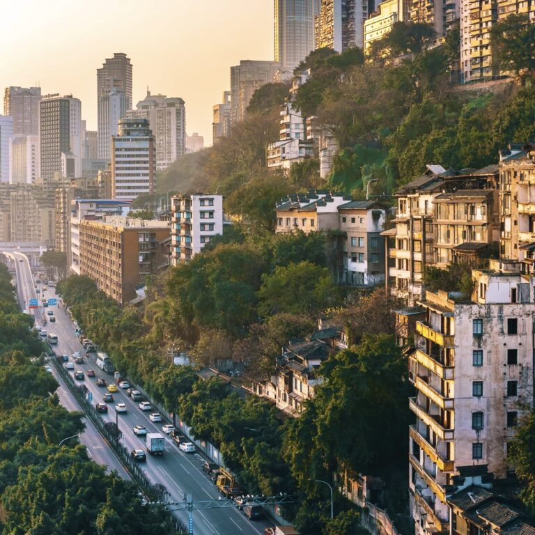
Chongqing is a quintessential mountainous terrain city. The entire city is built between hillsides and riverbanks. Unlike the flat grid layouts common in many plains cities, its roads form a stacked, three-dimensional structure. Two streets you see on a map might actually be one at the mountaintop and one at the foothills, separated by dozens of meters in elevation—creating Chongqing’s signature layered streets.
Because of this terrain, many first-time visitors experience these frustrations:
- Navigation shows only 200 meters, but you need an elevator or to climb a steep slope
- The same address might have an “upper entrance” and a “lower entrance.”
- The first floor of one building might actually be the tenth floor on another street
This is why many find Chongqing navigation “like a maze.” The city’s transportation system is specifically designed for this complex terrain. Subways, light rail, river cable cars, buses, and ride-hailing services all help visitors navigate the city more easily.
In this guide, I’ll help you understand several key questions from a local’s perspective:
- Why does Chongqing navigation seem complicated
- How Chongqing’s transportation system tackles mountainous terrain
- Best way to get around Chongqing for first-time visitors
Once you master using the subway, public transit, and local navigation apps, navigating Chongqing becomes easier—and transforms into a unique travel experience exploring the city.
Why Chongqing Navigation Feels Difficult for First-Time Visitors
Many friends ask me: Why is navigation in Chongqing so difficult? Is it because of poor satellite signals? No. In Chongqing, navigation isn’t just a technical challenge—it’s a physical one. You’re not dealing with a flat map, but a three-dimensional, folded-up “Inception.”
Chongqing Is a Multi-Layered Mountain City
Chongqing is a quintessential mountainous terrain city, built directly between peaks and valleys. This geography has forged an exceptionally multi-layered urban structure. As many visitors have genuinely remarked: You might be in the same hotel as your Didi driver, yet while you’re in the lobby on the first floor, the driver is at another entrance on the 20th floor.

A cross-section of Chongqing’s multi-layered city architecture where buildings have street-level entrances on different floors.
This vertical distribution means your destination might be just 50 meters below your feet, but you’d have to navigate around three buildings and take two elevators to reach it. This spatial disorientation is the core physical factor behind why Chongqing navigation is difficult.
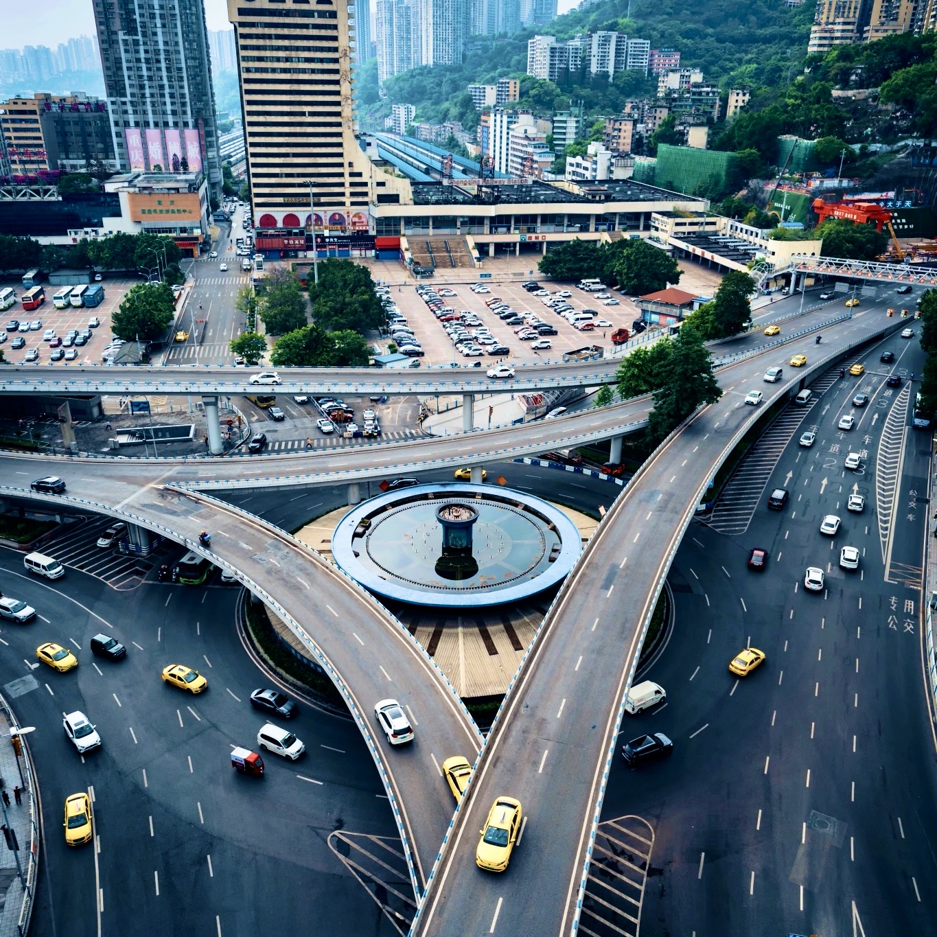
Complex Roads and Vertical Streets
As a vertical city, Chongqing’s road design defies all conventions. To overcome hundreds of meters in elevation, we’ve developed an extraordinarily complex road system. You’ll see rail transit passing overhead through buildings, while buses snake along cliff edges.
This is precisely why Chongqing’s streets are confusing. To connect these staggered elevations, the city developed unique hillside transportation systems—like the Crown Escalator or Ciqikou Escalator, built specifically for steep inclines. In other cities, these might be tourist attractions; in Chongqing, they’re essential solutions for vertical commuting.
Layered Streets That Confuse Navigation Maps
Chongqing’s layered streets make navigation challenging for first-time visitors.

The Huangjuewan Overpass in Chongqing is a complex transport hub with 5 layers and 20 ramps illustrating layered streets.
Imagine this: at the same GPS coordinates, there could be three entirely different layers of reality—one along the riverbank, one inside a tunnel, and one beneath an elevated highway. When you open your map, that little blue dot has no clue which layer you’re actually in.
If your navigation tells you to “turn left,” but the left side is actually a wall or a hundred-meter cliff, don’t be surprised—that’s because your navigation is on the second level, while your physical body is on the fifth. This is why in Chongqing, renting a car and driving yourself is more likely to get you lost in the interchanges and tunnels. Finding a reliable local driver often works better than relying on satellite maps.
Local tip: In Chongqing, instead of stubbornly following navigation, slip on a pair of comfortable flats and explore the mountain city’s pathways while asking locals for directions.
Is Chongqing Walkable? Walking Difficulty and Chongqing Stairs
As a Chongqing native who grew up climbing staircases on the mountain city’s pathways, I often see foreign tourists near Liberation Monument staring at their phone maps with that classic “Who am I? Where am I?” look. When asked if Chongqing is walkable, my answer is: It depends on your spirit for walking challenges. In Chongqing, navigation isn’t just a technical skill—it’s a physical one.
Why Chongqing Has So Many Stairs
In Chongqing, walking isn’t called “walking”—it’s called “climbing.” Stone stairs (Chongqing stairs) are everywhere, not for fitness but as a survival necessity. Built between mountains and valleys, staircases are the shortest routes connecting streets at different elevations.
As I mentioned earlier, Chongqing is a 3D magical city. You’ll encounter a surreal phenomenon: exiting a mall’s LG level, 1st floor, 2nd floor, or 3rd floor all leads directly onto a major street. This vertical distribution means your destination might be just 50 meters below your feet, yet you’ll need to navigate around three buildings and take two elevators to reach it. This spatial disorientation is the core reason why Chongqing navigation is so challenging.

A long and steep stone staircase known as the Chongqing stairs connects two different street levels in a traditional neighborhood.
Areas Where Walking Is Easy for Tourists
So is Chongqing walkable? In certain core scenic areas, the answer is a definite yes.
If you’re exploring the Mountain City Trail, Liberation Monument, or the Hongyadong area, walking offers the most breathtaking visual impact. Especially at sunset, strolling along the riverbank lets you avoid the crowds on the bridges and perfectly capture the moment Hongyadong lights up over the water. Additionally, areas like Danzishi or Ciqikou, steeped in old Chongqing nostalgia, are also ideal for exploring the city on foot.
When Walking in Chongqing Becomes Difficult
The difficulty of walking in Chongqing instantly skyrockets when you attempt to cross districts or end up on the wrong floor due to navigation errors.
- Elevation Gaps and Stamina: Steep slopes permeate the city. Without supremely comfortable flats, your knees will protest immediately. To aid residents climbing hills, the city even features massive escalators like the Crown Grand Escalator or Ciqikou Escalator—essential vertical tools for navigating Chongqing.
- Navigation Confusion: GPS often goes haywire on multi-level, overlapping walkways. You might be at the same hotel as your DiDi driver, yet you wait anxiously in the 1st-floor lobby while they wonder why you’re not at the 20th-floor entrance.
- Queueing Trials: Take the famous Yangtze River Cableway—the queue at North Station (near Liberation Monument/Hongyadong) is notoriously long, often exceeding 1-2 hours during peak times.

tourist checking a phone map while standing at a multi-level pedestrian bridge, reflecting the walking difficulty.
Local’s Guide to Avoiding Pitfalls: For easier getting around Chongqing, I recommend adopting “reverse thinking.” For instance, when taking the cable car, first take the subway to South Station (Shangxinjie Station) and board the northbound cable car from the less crowded South Station. Not only will you encounter shorter lines, but the sunset views are also the most breathtaking.
Transportation in Chongqing: The Easiest Way to Improve Chongqing Navigation
In Chongqing, choosing the right mode of transportation matters far more than knowing how to read a map. Drawing on my local experience, here’s a comprehensive guide to navigating Chongqing’s transit system.
Public Transportation in Chongqing
If you ask me the best way to get around Chongqing, the answer is always the Chongqing Rail Transit (CRT). Not only is it the city’s lifeline, but it’s also the most convenient and affordable way to travel.
The most famous monorail lines, Lines 2 and 3, glide directly over mountains and rivers. Especially at Liziba Station on Line 2, you’ll witness the unique spectacle of a light rail train passing through a building—something you won’t see in any other city. Public transport fares in Chongqing are remarkably affordable, typically ranging from 2 to 10 RMB based on distance. But as a local, I must warn you: due to the mountainous terrain, some subway stations are buried deep underground. You may need to navigate extremely long or multi-level escalators to reach the platform, so be sure to allow ample time.

A traveler using a mobile payment app to scan through a Public Transport Chongqing subway turnstile.
Bus System in Chongqing
If you want to immerse yourself in the local flavor of Chongqing, the bus system is a fascinating option. Buses can reach winding mountain roads and riverside communities beyond the subway’s reach, with fares typically just 2 yuan.
However, this might be the most challenging aspect of navigating Chongqing. Most buses feature only Chinese signage and announcements, and routes through the mountainous city are extremely steep and winding, requiring passengers to hold onto handrails at all times. For non-Chinese-speaking tourists, this presents a significant challenge.
Taxi and Ride-Hailing Options
In Chongqing, taxis and ride-hailing services are essential for tackling the “last mile,” saving you the effort of climbing steep hills and navigating uneven terrain.
- Taxi Tips for Tourists in Chongqing: Most taxis in Chongqing are yellow and operate on a meter system, with a base fare of approximately 10 RMB (for the first 3 kilometers).
- Ride Hailing China: We recommend downloading and using DiDi. Not only does it feature an English interface, but more importantly, it includes a built-in translation function that perfectly resolves language barriers when communicating with drivers at your destination with drivers. It also eliminates the hassle of cash transactions and change.

An iconic yellow Chongqing taxi is driving on a complex, layered bridge, showing taxi transport in the mountain city.
Professional Pitfall Guide: When navigating Chongqing, Didi drivers are usually more reliable than GPS navigation systems. As locals often say, renting a car and driving yourself makes it extremely easy to get lost in overpasses and tunnels. But remember: Before hailing a ride, always confirm your floor via the built-in chat feature! Sometimes you and the driver share the same latitude and longitude—yet you’re on the 1st floor by the riverbank while the driver waits at the 20th-floor entrance of an elevated highway. This “same city, different dimensions” encounter is precisely what makes Chongqing so surreal.
Chongqing Metro Guide: The Most Essential Tool for Navigating Chongqing
If you want to avoid getting lost in Chongqing, this tourist guide to the Chongqing Metro is your lifeline. Choosing the right mode of transportation matters far more than knowing how to read a map. In this 8D city, rail transit (CRT) is the only way to reliably bypass surface traffic jams and navigate the maze of overpasses.
How the Chongqing Metro System Works
Chongqing Rail Transit (CRT) is currently the world’s most complex mountain rail system. Mastering how to use the Chongqing Metro is actually quite simple: Mobile payments are highly prevalent citywide. You only need to activate the “Ride Code” in Alipay or WeChat, then scan it when entering and exiting stations to enjoy “ride now, pay later.”
Fares are remarkably affordable, typically ranging from 2 to 10 RMB. However, due to the terrain, some Chongqing Metro stations are deeply buried underground. Take the renowned Hongtudi Station, for instance—its depth is equivalent to a 31-story building. You may need to navigate multiple extremely long escalators to reach the platform.
Major Chongqing Metro Lines
Currently, Chongqing’s rail transit routes cover all core tourist attractions. If you’re visiting for the first time, these metro lines are essential to bookmark:
Here’s the Chongqing subway map you need.
- Line 10 (Purple): This is the most efficient option for traveling between Jiangbei International Airport (CKG) and downtown, offering direct access to transfer hubs like Hongqihegou.
- Line 1 (Red): Connecting Jiefangbei (Jiaochangkou Station), Eling Second Factory, and Ciqikou, it’s an essential route for exploring Old Chongqing’s cultural heritage.
- Line 6 (Pink): Takes you to Grand Theatre Station, the prime vantage point for capturing panoramic night views of Hongyadong.
The Famous Chongqing Monorail Experience
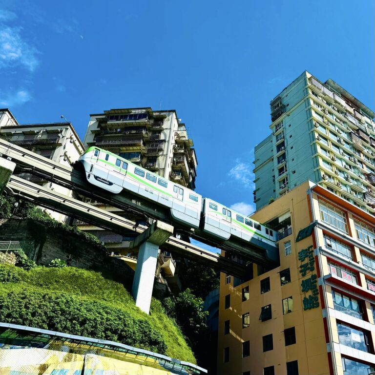
In Chongqing, riding the subway isn’t just commuting—it’s a visually stunning Chongqing monorail experience. Our Lines 2 and 3 feature suspended monorails that snake through mountains and skyscrapers like giant dragons.
The most iconic experience is undoubtedly Line 2’s Liziba Station, where the train literally passes through the belly of a residential building. This spectacle of a “monorail piercing a building,” combined with the breathtaking views of the train gliding above the Jialing River, is a classic moment no Chongqing navigation guide would miss.

The iconic Chongqing monorail experience showing a train passing through a building at Liziba Station, a highlight of Chongqing navigation.
Local Tips:
- Avoid rush hour: Line 3 gets extremely crowded from 7:30–9:00 AM and 5:30–7:00 PM.
- Check the last train: Most Chongqing metro lines stop around 10:30–11:00 PM.
- Best way to pay: Use Alipay QR code—it often works offline, which is convenient for travelers.
Unique Transportation Systems That Help Chongqing Navigation
In this 8D city, mastering Chongqing navigation means treating cable cars, elevators, and even ferries not just as Instagram spots, but as vertical commuting tools that help you hack your way through the three-dimensional maze. If those overlapping flyovers leave you dizzy, switch to these unique transportation modes in Chongqing. They’ll carry you across the Yangtze or lift you dozens of meters skyward, instantly saving you half a day’s worth of uphill effort.
Yangtze River Cableway
As Chongqing’s most iconic hillside transportation, the Yangtze River Cableway is hailed as the “sky bus.” It not only offers a bird’s-eye view of the confluence of the two rivers but also serves as a swift link between Yuzhong District and Nan’an District.
Regarding how to ride the Yangtze River Cableway, note the following: A one-way ticket costs approximately 20 yuan, while a round-trip ticket is about 30 yuan. Due to its immense popularity, booking is mandatory to secure tickets and obtain a queue number. Foreign visitors must carry their original passport at all times, as it is essential for ticket purchase and verification.

The iconic Yangtze River Cableway cabin is moving across the Yangtze River, a key feature of Chongqing navigation.
Crown Escalator
If you find yourself feeling hopeless near Lianglu Kou, the Crown Escalator is your savior. This massive 112-meter escalator was built to bridge the enormous elevation gap between streets. For just 2 RMB one way, it lets you ascend dozens of floors in mere minutes. For backpackers with aching legs, this is undoubtedly the most effortless solution to navigating Chongqing’s terrain.
Chongqing Ferry
Want to avoid the gridlocked crowds on Qiansimen Bridge? The Chongqing Ferry is the locals’ favorite. These commuter ferries offer extremely affordable fares (around 10-15 RMB), brimming with old-school Chongqing nostalgia. They provide an unbeatable vantage point for experiencing the city’s “cyberpunk” visual spectacle.
Ferry Routes in Chongqing
The most popular ferry routes currently operate between Hongyadong and Danzishi.
A single ferry ride takes just 15-20 minutes. I recommend boarding at sunset. As the ferry reaches the river’s center, you can escape the crowds on the bridge and perfectly capture the breathtaking moment when Hongyadong lights up from the water. Remember, boarding the ferry also requires purchasing tickets with your passport.

A traditional Chongqing ferry crossing the river at dusk, showing alternative ferry routes in Chongqing.
Local Tips:
- Cable Car Tips: Avoid queuing at the North Station near Jiefangbei/Hongyadong—waiting times may exceed 1-2 hours. Trust me: take the subway to Shangxinjie Station, then transfer from the South Station to the North Station.
- Escalator Safety: The Crown Escalator moves faster than typical mall escalators and has an extremely steep incline. Those with a fear of heights should hold onto the handrails. Primarily connecting the train station to the upper streets, it’s a genuine commuter tool.
- Best Time for the Ferry: For that cyberpunk vibe, head to Hongyadong at sunset to capture its dazzling lights.
Best Navigation Apps for Chongqing Navigation
I’ve taken countless foreign friends to hot pot in this mountain city, and their most common complaint is: “My map’s gone haywire again!” In Chongqing, choosing the right navigation apps for China can save you a lot of detours. This guide to Chongqing navigation tools is essential reading for all visitors to avoid pitfalls.
Does Google Maps Work in Chongqing
This is the top concern for many international visitors: Does Google Maps work in Chongqing?
Honestly, never rely on foreign mapping apps. Due to outdated data and a lack of 3D city modeling, they perform terribly when navigating Chongqing’s complex elevated walkways and multi-level exits. When it comes to navigating Chongqing, traditional 2D maps often leave you circling bridges or pointing straight at a wall.

Google Maps does not work in Chongqing.
Best Map Apps for Chongqing Navigation
If you ask me what the best navigation apps for Chongqing are, as a local, I recommend downloading these two essential apps for exploring the city:
- Amap Navigation: This is the top choice among locals. It excels at navigating Chongqing’s incredibly complex multi-level walkways and multi-exit structures, providing the most accurate real-time bus routes.
- Baidu Maps: Also a top-tier GPS navigation tool in China. Both apps accurately interpret Chongqing’s surreal logic of “one level along the river, one level in tunnels, one level on elevated roads.”
Navigation Apps for Traveling in China
For non-Chinese-speaking tourists, these map apps for China travel present a language barrier. To avoid major communication hassles, I recommend pairing them with translation tools:
- Prepare Pleco, Google Translate (requires a VPN), or Baidu Translate in advance.
- Save your destination in large Chinese characters on your phone. This way, when facing Chongqing navigation challenges, you can directly show it to taxi drivers or locals.

Using the AutoNavi app in Chongqing, paired with a translation tool, to navigate the city’s multi-layered streets.
Local Tips:
- Avoid “blind confidence”: If Amap navigation says you’ve arrived but you see nothing, look up or down—Chongqing has significant elevation changes.
- Ask locals for directions: No matter how advanced your Baidu Maps is, sometimes locals are more reliable than navigation apps.
- Battery Backup: GPS navigation in China and translation apps drain power quickly. Always bring a power bank before heading out.
In Chongqing, many street vendors accept QR code payments. Mastering mobile payment systems in China is crucial—it’s also the best solution for navigating Chongqing.
How to Pay for Public Transportation in Chongqing
In Chongqing, while cash is still accepted, this “primitive” method might cause you to miss that monorail just pulling into the station, since most drivers don’t give change and machines don’t accept large bills. Now, whether you’re taking the subway, bus, or ferry, the most authentic way is to “have your device ready and go whenever you want.”
Using Alipay Transport Code
For foreign visitors, we recommend using the Alipay Transport Code. You won’t need to queue up and figure out those complicated ticket machines, nor worry about having the right change.
Regarding how to pay for the metro in Chongqing, the process is straightforward: In Alipay, tap “Transport,” locate Chongqing, and activate your transport code. When passing through the gates, simply scan this transport QR code. The system will use a “pay later” model, deducting the fare directly from your linked international credit card. This is undoubtedly the best solution for metro payment for tourists in China.

A traveler using the Alipay transport code on a smartphone to pass through a Chongqing Rail Transit gate.
Using WeChat Pay for Transportation
If you’re accustomed to using WeChat, WeChat Pay Transport is equally convenient. Search for “Chongqing Public Transport QR Code” in the WeChat Mini Programs. The activation process is very similar to Alipay.
Using Alipay or WeChat Pay for public transportation not only ensures a seamless experience on rail transit (CRT), but these dynamic QR codes also work on most Chongqing buses (typically costing 2 yuan). Even when boarding nostalgic Chongqing ferries (like the Hongyadong to Danzishi route), scanning the code lets you skip the ticket window lines.

Use the WeChat Transit Code on your smartphone to pass through the gates of Chongqing Rail Transit.
Local Tips:
- Subway QR Codes: Chongqing’s subway QR code system is highly advanced. Even if your phone temporarily loses signal, the ride code can usually be generated offline and scanned to open turnstiles. For peace of mind, however, we recommend opening the app and preparing your code before descending to the lower-level platforms.
- Skip Physical Cards: Avoid purchasing physical transit cards like the EZ-Link card (Yikatong). The card refund process is extremely cumbersome, and scanning your phone QR code also allows you to enjoy transfer discounts after bus fare deductions.
- Original Passport is Essential: While payments can be handled via phone, legal requirements mandate identity verification when riding the Yangtze River Cableway, taking Liangjiang River cruises, or purchasing high-speed rail tickets. Always carry your original passport; having only a photo stored on your phone may not suffice.
People Also Ask: Chongqing Navigation FAQ
Is Chongqing difficult to navigate?
Yes. Chongqing navigation is complex due to the mountainous terrain and layered streets. GPS may place you above or below your destination. Use Chongqing Rail Transit (CRT).
Is Chongqing walkable?
Yes, but expect many Chongqing stairs. Wear flat shoes and use the Crown Escalator or the Yangtze River Cableway.
Best way to get around Chongqing?
Use Chongqing Rail Transit (CRT) (2–10 RMB). For direct trips, use Didi
Does Google Maps work in Chongqing?
Not well. Use Amap (Gaode) or Baidu Maps for accurate GPS navigation in China.
In short, Chongqing truly is a magical city that can make even the most advanced satellite navigation systems question their existence. But don’t be intimidated by the overlapping flyovers and countless stone staircases—Chongqing navigation isn’t nearly as daunting as the rumors suggest. Once you let go of your fixation on flat, two-dimensional maps and adopt a three-dimensional perspective, this city will deliver an unprecedented visual spectacle.
Transportation in Chongqing – Key Tips
- Use Chongqing Rail Transit (CRT) for major travel across elevation changes.
- Use Amap (Gaode) or Baidu Maps for layered streets navigation.
- Use DiDi for the last 100 meters and built-in translation.
Extra tips:
- Wear comfortable flat shoes.
- Carry your passport.
- Ask locals, “Which floor?” when navigating Chongqing’s 8D city.
After all that, is Chongqing hard to navigate? Once you master these tips, you’ll find getting around Chongqing isn’t just longer a painful maze challenge—it becomes a cyberpunk adventure full of surprises. As a local, I hope this helps you get around Chongqing like a pro, letting you roam freely through this 8D city without getting lost.